
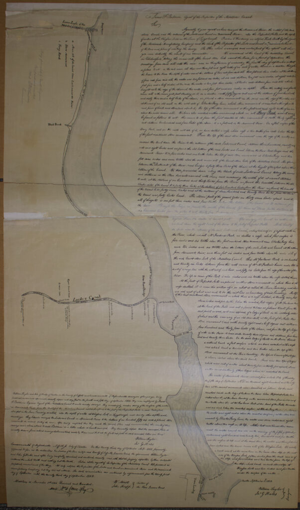
In September, 1822, James F. Baldwin, the agent of the Middlesex Canal, hired surveyors William Taylor and John G. Hales to conduct a survey and make soundings in the vicinity of Pawtucket Falls on the Merrimack River. When finished their measurements, the surveyors presented Baldwin with a sketch that showed and a letter that explained their findings. The plan was recorded at the Middlesex County Registry of Deeds which was then in Cambridge.
In 1855, when the Middlesex North Registry of Deeds in Lowell was created, clerks reviewed all documents and plans previously recorded in Cambridge, and made copies of all documents and plans that depicted land that was in the communities that made up the new Northern Registry.
Among the documents copied was the 1822 survey which contains both the sketch and the text of the letter. (It is unclear if the original recording combined the sketch and the letter or if this combination is the work of the copyist in 1855.)
The following is a recent transcription of the verbiage contained on the copied plan.
Richard P. Howe Jr., Middlesex North Register of Deeds
December 21, 2023
Middlesex South Plan Book 5, Plan 7
(At Middlesex North Registry of Deeds
For a higher resolution copy of the image, please visit
https://libguides.uml.edu/early_lowell/merrimack_river_survey_1822
To James F. Baldwin, Agent of the Proprietors of the Middlesex Canal
Sir
Agreeably to your request we have surveyed the Merrimack River, the outlet of the Middlesex Canal, and the entrance of the Locks and Canal on Merrimack River – also the Patucket Falls, and the depth of the water at the Wicassee Locks in the Town of Tyngsborough. Previous to this survey we notified Kirk Boott, Esq., the Agent of the Merrimack Manufacturing Company and the clerk of the Proprietors of the Locks and Canal on the Merrimack River of the time and place of making the survey. The Plan which is annexed and makes part of this report will show you more distinctly the result of our examination.
We commended at the head of the Middlesex Canal in Chelmsford, taking the main sill of the lowest stone lock nearest the River, for a point of departure: the sounding from said sill into the river were in the afternoon of Wednesday, the fourth day of September instant, as follows to wit on the said main sill there was three feet and eight tenths of an inch of water, thence in a direction through the basin to the River the depth of water was at the distance of two rods from said sill three feet and eleven inches; at the distance of four rods from said sill, the water was two feet and six inches; at six rods distance, two feet nine inches; at eight rods two feet five and a half inches; at ten rods the water is two feet three inches; at twelve rods distance from said sill which brought us to the edge of the channel, the water was four feet and six inches in depth.
From the easterly end of said main sill or the main gate post standing on it, in a direction north fifty ¼ degrees east and at the distance of four hundred and sixty three and a half links of the chain, we placed a stone monument in the sand near the edge of the water, and at the end of an old wall on the west side of Clarks Ferry lane; which stone monument is marked with a cross on it and pieces of brick and stones laid about it; the top of this stone monument is three feet and eight tenths of an inch about the said main sill.
We have also marked another monument which we call Ferry Rock, and it may be found as follows to wit; the course to it from the first mentioned stone monument is northerly eight degrees east distance two hundred and four links of the chain; it is a fast rock in the Merrimack River. On a flat surface of this Ferry Rock and on the north west side of it, we have drilled a cross which cross is two tenths of an inch below the top of the first mentioned stone monument.
From the top of said stone monument near the edge of the water, we carried the level down the River to the entrance of said Locks and Canal, distance three hundred seventy six rods and eight links and we found the old bottom of the said Locks and Canal between the River Road Bridge and the Merrimack River to be five inches and one tenth below the top of said stone monument at Clarks Ferry and two feet seven inches and seven tenths above the said main sill of the lowest stone lock of the Middlesex Canal. The space between the stone abutments of the River road bridge is forty three links of the chain at the height of two feet above the bottom of the Canal.
We then proceeded down along the trunk of said Locks and Canal taking the courses and distances as the Plan here unto annexed will show, and measuring the width of it at several stations, to wit, at the distance of one hundred thirty links from the River we found the breadth between the old timber sides of the Canal to be forty three links; at the distance of five hundred links from the River we found the breadth of the Canal to be forty seven links; and at the distance of eleven hundred and twenty tree links from the River the Canal was forty links broad.
The main posts of the guard gates are thirty seven links apart and the sill of the gates is one foot three inches and four tenths below the bottom of the Canal at its entrance from the River. Through the Ledge we found the width of the Canal as [illegible] for the distance of six hundred links from the gates, to wit, thirty four [illegible] higher than the center of the lowest post.
After surveying this Canal we continued our level down the right bank of the River to the foot of Patucket Falls. At the head of the Falls near the entrance of the said Locks and Canal, on the flat surface of a fast rock in the River which we call McFarlane’s Rock, we drilled a cross which flat surface is five inches and six tenths above the first mentioned stone monument near Clark’s Ferry lane and ten inches and six tenths above the bottom of said Locks and Canal at the entrance from Merrimack River; and three feet six inches and four tenths above the main sill of the said lowest stone Lock of the Middlesex Canal.
This McFarlane’s is one hundred and twenty six links distance from the west corner of Mr. McFarlane’s house and a little to the west of a range line with the west end of said house, and fifty six links from the edge of the water of the River. The top or crown of this Rock is nine inches and six tenths above the cross drilled thereon.
At the foot of Patucket Falls we placed another stone monument on which there is a cross drilled. It is near the water’s edge, on what is called the Town Landing, and about one rod west of what was said to be the east line or boundary of said landing. The top of this last mentioned stone monument on which there is a cross drilled, is twenty nine feet eleven inches and five tenths below the marked flat surface of McFarlane’s rock at the head of the Falls and will be found to bear as follows to wit: from the east point or end, as it now appears, of a ledge of Rock on the southerly side of what was the race-way of an old saw mill at the foot of the Falls, this stone monument bears north seventy eight and a half degrees east, distance four hundred and thirty four links of the chain, and from the top of a ledge of rocks in the River, it bears south twenty three degrees east, distance four hundred and twenty three links. On the said ledge of Rocks in the River, there is a natural bench or flat surface which we have marked with a cross and which bench is two inches and two tenths above the top of the stone monument at the Town landing. The top or crown of this ledge is eleven inches above the said bench. There were two tops of ledges which were out of water about twenty five or thirty feet apart; it was on the most southerly of these ledges where we marked the bench.
The water of Merrimack River was at four o’clock, P.M. on Thursday, the fifth day of September A.D. one thousand eight hundred and twenty two at the several monuments above described as follows:
At the said Market bench on the ledge of Rocks in the River below Patucket Falls, two inches above it;
At the Town landing on the monument stone four inches and two tenths above it;
At McFarlane’s Rock at the head of the Falls, the water was one inch below the marked surface;
At Clark’s Ferry Rock [illegible] the water was eight inches above the marked surface;
At the stone monument by Clark’s Ferry lane, the water was seven inches and eight tenths above the cross on its top.
At this last mentioned stone monument, the water was at sunrise on the morning of the fifth of September one thousand eight hundred and twenty two, two inches and five tenths over the cross on its top and at the same time, the water was three feet and four inches over the lower main sill of the Wicassee Lock.
We made a bench mark at the same time on the lower stone step on the west side of the Wicassee Lock, fifteen inches from the south corner of the step; which bench on said stone step at Wicassee Lock was two inches and five tenths under the surface of the water.
Boston, September 5th, 1822
William Taylor and John G. Hales, Surveyors
William Taylor and John G. Hales of Boston in the County of Suffolk and Commonwealth of Massachusetts surveyors of lawful age, being produced, sworn and examined, severally depose and say that on the fourth and fifth days of September 1822, they were employed by James F. Baldwin, esquire, Agent of the Middlesex Canal, to make sundry surveys. They accordingly made a survey of the surface of the water in Merrimack River from the outlet of the Middlesex Canal at Chelmsford to the foot of the Patucket Falls in said Chelmsford at a spot in the Town landing, so called. Also the depth of water at Wicassee Lock in Tyngsborough and sundry other depths and soundings. They likewise surveyed the Locks and Canals on Merrimack River to the distance of one hundred fifty six rods and placed stone monuments in various parts of the river. After having completed this, they made the annexed plan and communicated the result of their surveys and observations to said Baldwin in a letter which is hereto annexed. They severally depose that the annexed Plan is correctly drawn from actual surveys and observations made by them and that all the facts set forth in said annexed letter are true.
William Taylor
John G. Hales
Commonwealth of Massachusetts
Suffolk, ss. City of Boston
On this twenty third day of September A.D. 1822 personally appeared before us the subscribers two Justices of the Peace in and for said County of Suffolk, Quorum Annus, the aforementioned William Taylor and John G. Hales, and after being carefully examined and cautioned, severally made oath that the foregoing deposition by them subscribed contains the whole truth and nothing but the truth.
Taken at the request of the Proprietors of the Middlesex Canal to be preserved in perpetual remembrance of the thing. We duly notified the Proprietors of the Locks and Canals on Merrimack River and the Merrimack Manufacturing Company but they did not attend. The said examination was continued by adjournment from the twenty first day of September until the twenty third day of September 1822.
W. Minot and John Knapp, Justices of the Peace Quorum Annus
Middlesex SS, November 1st, 1822. Received and Recorded:
Attest: William F. Stone, Register.